- The foundation transfers the home’s weight to its supporting ground; ask about both.
- A hazard map, a site investigation and a structural assessment answer different questions.
- Seasonal frost and permafrost are different conditions; obtain local evidence before a support or site change.
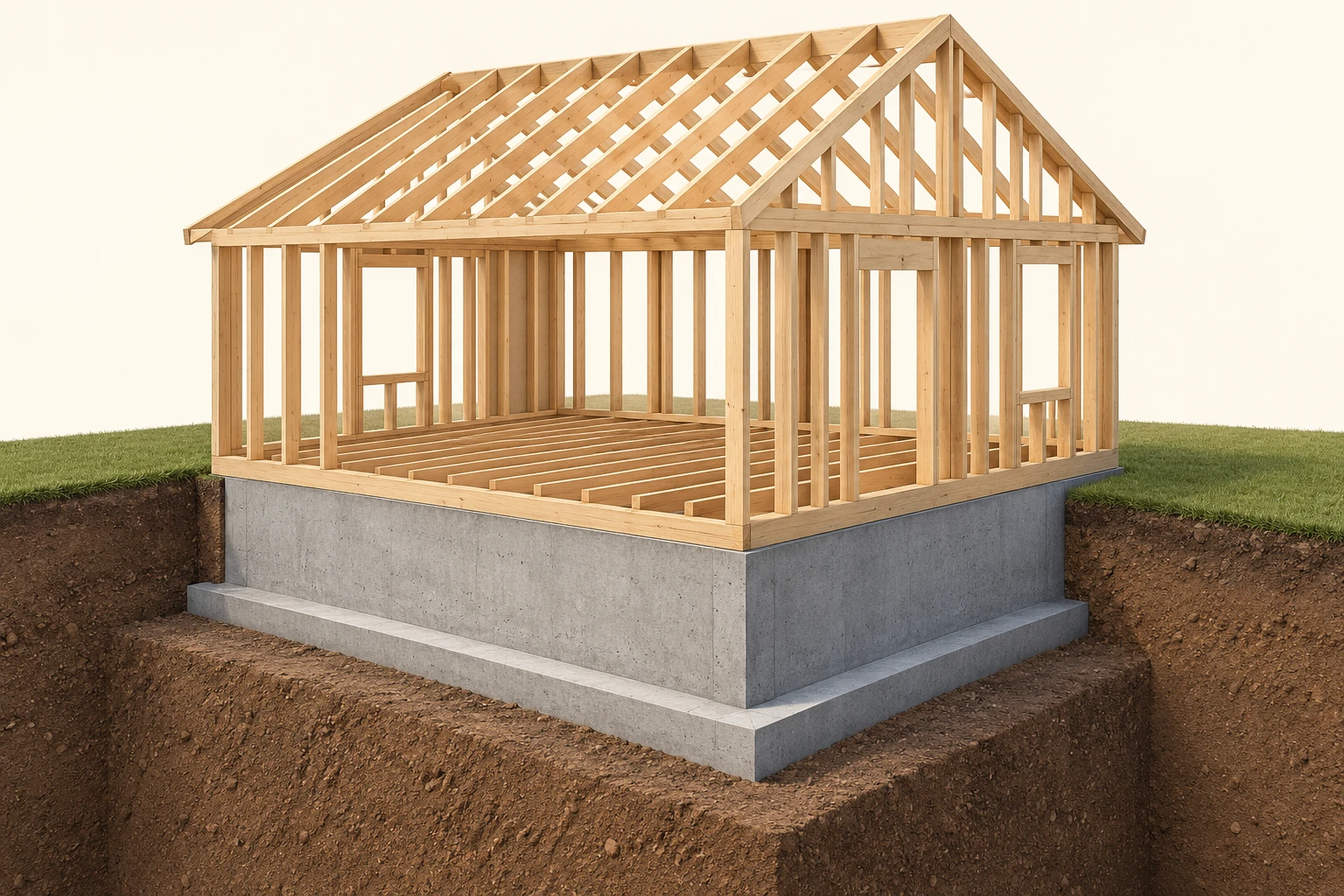
The timber framing, concrete foundation and wider footing form connected parts above the supporting ground. Each part belongs in the question of how this home is supported.
About this illustration
The cutaway gives no load, soil capacity, dimensions, fastening design, movement measurement or assessed structural condition. It is a generic support example, not a northern foundation recommendation. This is a conceptual teaching model, not an assessment of your home.
4 picture lessons appear beside the questions in this guide. Use them to understand the explanation, then consider what it means for your home.
What holds this home up?
The floor, walls and roof pass the house’s weight through its structural parts to the foundation. The foundation then transfers that weight to the supporting ground. Buying a home means asking about both: the condition of the building’s support system and the ground that system relies on.
A basement wall, a slab and raised supports are different arrangements. Ask the seller for drawings, ground reports, foundation work and later additions that match the present house. Have the appropriate professional explain the actual arrangement. A familiar-looking concrete wall does not identify the ground beneath it.
Start with your intended decision. Are you buying the home as it stands, planning an addition or changing drainage or landscaping? Tell the specialist which decision needs support. A report prepared for one small project may leave a larger proposed change outside its assessment.
Observe only accessible areas from normal safe positions, with permission. Stay out of crawlspaces and off unstable surfaces. Do not excavate, adjust supports or test the structure yourself. Photographs and a showing help you describe the question; the responsible professionals choose the investigation and interpret the findings.
Follow the house framing to the foundation and ground
The timber framing, concrete foundation and wider footing form connected parts above the supporting ground. Each part belongs in the question of how this home is supported.
Numbers identify the parts explained below.
- House framing
Floors and walls form part of the building structure. The actual connections and changes need their own assessment.
- Foundation and footing
The concrete wall and wider base introduce support below the framing. The picture does not establish their suitability for a property.
- Actual ground
The soil is illustrative. A regional map or house age cannot substitute for information about the ground beneath this building.
What does this illustration leave out?
The cutaway gives no load, soil capacity, dimensions, fastening design, movement measurement or assessed structural condition. It is a generic support example, not a northern foundation recommendation. Use accessible records and qualified ground or structural advice. Do not excavate, enter unsafe spaces or infer a repair design from the picture.
What supports this house, which ground information applies to this parcel, and what remains outside the assessment?
Explore this with HomeAI ↗Opens an editable question. Nothing is sent until you choose to send it.Does a crack show that the house is still moving?
A crack is a visible change in a material. A movement history describes how locations changed over time. One photograph can identify a mark and where it appeared, but it cannot establish its rate of change, age or cause. Keep those questions separate when reading a listing or inspection report.
Ask when the mark was first noticed, whether it changed and whether repairs or assessments followed. Preserve a seller’s explanation as reported history until matched records support it. A painted patch can prompt a records request without establishing concealed damage or deliberate concealment.
Foundation movement, changes in finishes and other material behaviour can need different explanations. Give the specialist the complete observations instead of naming the cause in advance. A sticking door or sloping floor adds context, but the Northwest Territories guide explicitly warns that house shifting there is not always caused by permafrost.
If monitoring is recommended, ask what is being measured, where the reference points are, which dates and conditions matter and who interprets the changes. A buyer’s photo collection is useful history; it is not an engineering diagnosis. Ask how inaccessible areas or missing earlier measurements limit the answer.
What does an earthquake map tell me about this address?
An earthquake can move the ground and place demands on a building’s structure and connections. A seismic hazard map describes modelled ground-motion information over an area. The separate building question is how this particular house may respond, given its construction, alterations and actual site conditions.
NRCan’s retained 2020 map set is a national overview, not a picture from which to read a parcel’s design values. The page says the colour scale changes between maps and directs individual-site values to its tool. Site designation and probability assumptions affect the values. Ask the professional which product and assumptions fit the assessment.
The map page and NRCan’s home-stand-up page display a March 2019 modification date. Use their explanations of scale, structural parts and local soil questions; do not treat them as current code-adoption or retrofit instructions. The edition named in a tool and the requirements applicable to today’s project need separate confirmation.
Write down three questions: what does the map describe, what ground information applies to the parcel, and what has been assessed in the building? A map colour cannot complete the other two jobs. Have the qualified specialist explain what the available information supports and which question remains unanswered.
A map, the ground and the house answer different questions
Three labelled question boxes connect a map’s scope, the actual ground and the building’s assessed support.
Numbers identify the parts explained below.
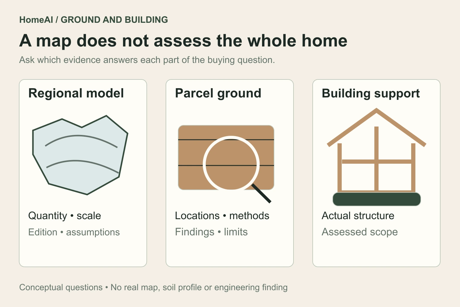
- Read the model
Identify the mapped quantity, edition, scale and assumptions.
- Match the parcel
Ask which ground locations and methods were investigated.
- Assess the building
Keep its actual support and connections in the stated structural scope.
What does this illustration leave out?
The generic drawings show no real map, soil profile, investigated location or structural finding. Ask for the actual products and complete reports. Conceptual record-reading aid. NRCan’s retained 2020 map set is small-scale; its displayed March 2019 date is separate from present local adoption.
Which record answers each question, and which part of the buying decision remains open?
Explore this with HomeAI ↗Opens an editable question. Nothing is sent until you choose to send it.Ask all three questions.
A regional model, local ground investigation and actual building assessment describe different subjects. Keep their original scopes and dates.
- Regional model
- Its job: Describes its mapped quantity, scenario, scale and assumptions.
- Next question: Which product and edition apply, and what does the map leave outside its scope?
- Parcel ground
- Its job: A ground investigation describes its locations, methods, findings and limits.
- Next question: Does the actual report match this parcel, foundation and intended work?
- Building support
- Its job: A structural assessment addresses the actual support and connections within its agreed scope.
- Next question: What was assessed, which later changes matter and what remains inaccessible?
The generic map has no real geography or numerical values. NRCan’s map explanation identifies scale, colour and assumption limits; a site or structural answer needs its own assessment.
Three questions, three kinds of evidence
- Regional mapExplains its mapped quantity, scenario, scale and assumptions. Ask which edition and geography apply.
- Actual groundA site investigation explains its methods, locations, findings and limits. Ask what matches this parcel and intended work.
- Building supportA structural assessment examines the actual support and connections in its stated scope. Ask which areas and changes it covers.
- Buying decisionCoordinate the unresolved questions and actual timing with technical and transaction advisors; no map colour completes the other jobs.
What can a ground investigation add?
Ground materials and conditions influence how a foundation is supported and how earthquake motion reaches a structure. A geotechnical professional studies the ground for a defined site and question. A structural professional studies the building’s support and connections. The two kinds of work can inform each other without being interchangeable.
Request the complete ground report, its site plan and the project it was prepared for. Ask where observations or samples were taken, which methods were used and which areas were not investigated. A report for a nearby lot or a past addition should not silently become a report for every part of this house.
Ask the author or current qualified professional whether the report is useful for the present decision and what further work is needed. A borehole record describes its investigated location and method. Its interpretation, connection to the actual foundation and important limitations belong with the complete report.
Water and land changes may add a separate site question. NRCan explains that flood maps can show different scenarios, extents or consequences. Check the map’s type, date and coverage, then obtain the parcel-specific answer needed. A flood layer does not establish foundation performance, private drainage condition or insurance availability.
Does this home actually rely on permafrost?
Permafrost is ground that remains frozen for at least two years. It can contain soil, rock and ice. In some northern arrangements, the building’s support depends on frozen-ground conditions. The buyer’s first question is whether that applies here, and what actual ground and foundation evidence explains the design.
The Northwest Territories’ 2015 homeowner guide explains that thawing excess ground ice can lead to settlement. The amount and location of ice matter; a northern address does not establish either. Ask for the site-specific assessment and the support arrangement it evaluated, rather than diagnosing the lot from vegetation or a map.
Request records of changes to supports, drainage, the space below the home and nearby ground. Tell the specialist about planned changes as well as completed ones. Ask which of them could affect the site’s thermal or water conditions and whether the original assessment still fits the present arrangement.
Use the Northwest Territories’ 2015 guide as regional education. Nunavut’s current overview points to permafrost resources; those linked maps have not been reviewed here. Both are starting points for questions. Neither supplies a national foundation recipe, current parcel finding or permission to alter supports, skirting or soil.
A frozen-ground concept is a starting question
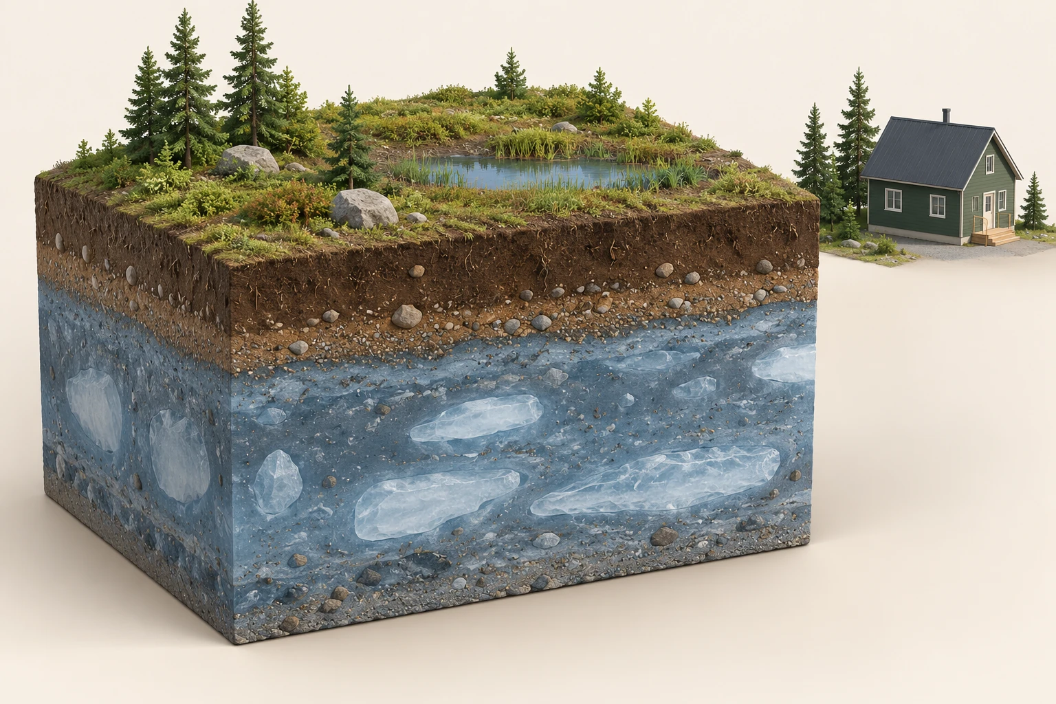
The coloured zones and ice shapes introduce surface and deeper-ground questions. The separate house is context; the block is not a surveyed profile beneath it.
Numbers identify the parts explained below.
- Surface zone
A surface observation belongs to its location and date. The labelled diagram elsewhere in this guide explains seasonal freezing and the active layer.
- Deeper frozen-ground concept
Persistent frozen ground is a condition across years. Its presence and condition at an address require actual local evidence.
- Property question
The house is separate from the teaching block. Ask what investigation describes the relevant ground beneath the actual building.
What does this illustration leave out?
Colours, thickness and ice shapes are illustrative. They establish no actual permafrost location, active-layer depth, temperature, thaw movement or suitable foundation design. This conceptual scene recommends no pile, pad, excavation, insulation or drainage intervention. Local ground and building assessment must guide proposed work.
What evidence establishes whether this property relies on permafrost, and which ground and building conditions were investigated?
Explore this with HomeAI ↗Opens an editable question. Nothing is sent until you choose to send it.How is seasonal frost different from permafrost?
Seasonal freezing and thawing describe a recurring change near the ground surface. Permafrost describes ground that stays frozen across years. Where permafrost exists, an active layer above it can thaw and freeze seasonally. A frozen surface during a winter showing therefore does not establish permafrost beneath the home.
Frost heave is upward ground movement associated with ice forming in the soil; thaw settlement is downward movement associated with ice melting. The Northwest Territories guide explains these different mechanisms. Seeing an uneven surface alone does not show which occurred, how much movement happened or whether the foundation was affected.
Ask whether observations span relevant seasons and whether the professional’s investigation distinguishes surface conditions from deeper support conditions. Keep the measurement location, method and dates attached. “The ground was frozen” is useful context only when the record explains what was actually observed or measured.
Do not dig for frozen ground or change water, snow, vegetation or enclosure arrangements as an improvised test. Some historical guide suggestions are maintenance or construction interventions; this buyer guide does not turn them into owner instructions. The local qualified team should determine the safe investigation and any address-specific proposal.
A winter surface does not establish permafrost
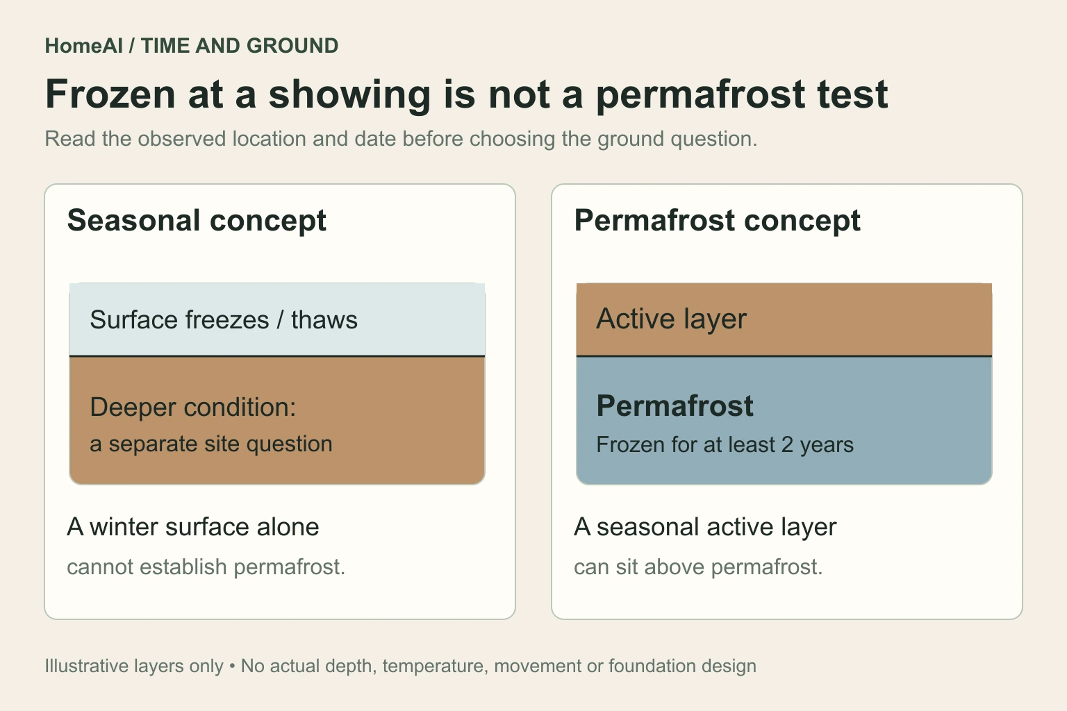
The seasonal concept and the permafrost concept have separate labels and different time questions.
Numbers identify the parts explained below.
- Seasonal change
A surface observation describes its own location and time.
- Active layer
Where permafrost exists, the layer above it changes seasonally.
- Persistent frozen ground
Permafrost remains frozen for at least two years; geography alone cannot establish it beneath this house.
What does this illustration leave out?
The diagram measures no depth, temperature, ice amount or movement, and selects no foundation or maintenance intervention. Actual ground conditions require local investigation. Original concept drawing informed by the Northwest Territories’ 2015 guide. It supplies no actual depth, climate forecast, footing detail or universal northern design.
What evidence separates a winter observation from the ground conditions supporting this home?
Explore this with HomeAI ↗Opens an editable question. Nothing is sent until you choose to send it.A surface observation is a starting question.
The Northwest Territories’ 2015 guide explains seasonal change, the active layer and permafrost. These conceptual categories do not identify the ground under a particular house.
- Seasonal surface freezing
- Its job: Ground near the surface can freeze and thaw through seasons.
- Next question: What location, date and method does the observation describe?
- Active layer
- Its job: Where permafrost exists, the layer above it can thaw and freeze seasonally.
- Next question: What actual investigation distinguishes this layer from deeper support conditions?
- Permafrost
- Its job: Ground remains frozen for at least two years.
- Next question: What evidence establishes its presence and condition beneath the relevant part of this property?
No dimensions, measured temperatures, foundation choice or maintenance recipe are supplied. A qualified local assessment establishes the actual support conditions and any proposed change.
Frozen ground does not mean one condition
- Seasonal frostSurface ground freezes and thaws through seasons; a winter observation alone does not establish permafrost.
- Active layerWhere permafrost exists, the layer above it can thaw and freeze seasonally. Actual depth and behaviour need site evidence.
- PermafrostGround remains frozen across at least two years. Northern geography alone does not establish it beneath a particular home.
- Movement questionFrost heave and thaw settlement describe different mechanisms. A visible mark does not diagnose which mechanism affected a building.
Who should assess the ground and the building?
Give the qualified team the house identity, intended use, available ground and foundation records, later changes and dated observations. State the uncertainty in ordinary language: for example, “Why were these supports adjusted, and what does that mean for the addition we are considering?” That is more useful than declaring a thaw or earthquake defect.
Ask whether the work needs geotechnical, structural or coordinated scope. Have each professional explain the deliverable, access required, exclusions and relationship to the other report. A general home inspection can help identify a question without supplying every specialist measurement or design conclusion.
Your realtor can coordinate authorized document requests and access; confirm any particular training or specialist availability. The technical team interprets its findings, while your legal and transaction advisors address the actual purchase terms and deadlines. Ask the insurer separately about this address and the coverage being considered.
Obtain scoped proposals for further investigation or recommended work. Ask which concern is being addressed, what access and restoration are included and how completion will be checked. Two prices attached to different questions are not direct alternatives, and a support-adjustment invoice is not a full ground-and-building assessment.
If the structure appears immediately unsafe, keep people clear and get appropriate emergency or qualified help. A routine inspection booking is not a safety clearance. Do not continue a showing or start monitoring as a substitute for responding to the immediate concern.
What should I keep before buying or changing the home?
Keep the full ground and structural reports, drawings, monitoring history and completed-work records together. Preserve each author’s date, purpose and limitations. A future designer should be able to distinguish a recommendation, a performed task and an assessed finding without relying on an optimistic one-line summary.
In the fictional example below, an adjustment invoice is retained as an adjustment record. The unanswered question is why that work was needed and what the present arrangement requires. The buyer asks for the appropriate records and assessment; neither the invoice nor the missing papers establishes a failure.
If important evidence cannot be obtained before the actual purchase deadline, seek transaction advice about the available options. Time pressure does not improve the evidence. Keep a consequential uncertainty visible when comparing the price, proposed use and cost or availability of further investigation.
After possession, carry the address-specific professional plan forward when changing the building or site. HomeAI can explain the parts and organize questions. It cannot certify foundation support, select a northern footing design, predict an earthquake outcome or diagnose the ground from a regional map.
Practice the distinction.
An adjusted support and an unanswered reason
Fictional buyer Mira is considering a northern home and a later addition. The seller supplies an invoice naming adjusted supports and reports that a door once stuck. No matched ground report or explanation of the adjustment has been supplied.
Reported observations
- The invoice describes an adjustment task and its stated supports.
- The reported door history has no supplied dated measurement sequence.
- The intended addition has not been assessed in the supplied documents.
Compare the explanations
Expand each possibility to see the evidence needed to distinguish it. Similar symptoms can have different mechanisms.
A documented task with a limited job
The adjustment may have been appropriate within an actual support plan, while its invoice leaves the reason and wider condition unanswered.
The matched design, complete job scope, related findings and relevant monitoring history.
A decision that needs coordinated assessment
The present ground, foundation and proposed addition may require questions outside the adjustment job.
An agreed geotechnical and structural scope for the actual site, building and intended work.
A useful next question
Mira asks the seller for complete records, gives the qualified team her intended addition and obtains transaction advice about the actual assessment timing.
This example is invented. It diagnoses no permafrost, thaw, settlement, earthquake damage, unsafe foundation or concealment, and selects no foundation design.
Know what the words mean.
- Geotechnical
- The study of ground materials and behaviour for a defined site and engineering question. Ask which locations, methods and proposed use were covered.
- Seismic hazard
- Modelled information about potential earthquake ground motion. A separate building assessment addresses the actual structure and its response.
- Permafrost
- Ground that remains frozen for at least two years. Its presence and local condition require evidence rather than a northern address alone.
Questions to bring
to the conversation.
- What arrangement supports this home, and which records match its present construction?
- What do the dated observations show, and who assessed the remaining movement question?
- Which map edition, site assumptions and investigated locations belong to the answer?
- Which ground and structural scope is needed for the purchase or proposed change?
Separate a showing observation, an existing record and a new professional assessment. Unknown means a question remains; it does not automatically mean a defect.
Use the evidence planner ↗Go to the source.
Original HomeAI explanation informed by these public references. Sources support the underlying guidance; they have not reviewed or endorsed HomeAI. Diagrams are conceptual, and calculator outputs depend on your inputs.
References read for this refresh on October 5, 2026. NRCan’s retained National Building Code 2020 maps have a displayed March 2019 page date and small-scale model scope. The NWT retained route leads to a ©2015 guide; Nunavut material is northern context. A regional map cannot establish the ground or foundation condition of this parcel.
Publication & source review
First published .
Sources reviewed .
- Natural Resources Canada · Seismic hazard maps and their scale limits
- Natural Resources Canada · How would your home stand up?
- Government of the Northwest Territories · Living on Permafrost: homeowner guide
- Government of the Northwest Territories · Homeowner’s guide to permafrost
- Government of Nunavut · Climate Change Secretariat
- Natural Resources Canada · Flood mapping types and process
Have a question about your home?
Start with the symptom, timing and what you have observed.
Ask HomeAI